


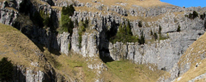
 Karst landforms are those produced by the weathering and erosion (denudation) of limestone. Glaciokarst was formed by ice eroding the overlying soil and weathered rock to expose the limestone below, allowing it to be chemically weathered by slightly acidic rain and soil water. Limestone pavement has been produced where weathering has been concentrated along the vertical joints forming fissures or grikes separated by blocks or clints (18). The Yorkshire Dales National Park contains approximately half of all Britain’s limestone pavement.
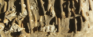
 Where vertical fissures have been enlarged larger depressions called dolines are formed. Shakeholes or subsidence dolines occur where a cover of soil or glacial deposits gradually subside into the doline forming a small depression. Swallow holes or sinks are formed where streams flow into vertical fissures or dolines. As the water moves underground the joints and bedding planes which it follows may be enlarged through chemical weathering and may eventually form caves (20).

Map: YDRP Caves – The majority of the caves are formed in the Malham/Danny Bridge Limestone Formations of the Great Scar Limestone Group.
 Stalactites and stalagmites (speleothems) have formed in the caves and radiometric dating of the speleothems in the caves has indicated at least three major phases of formation dated at approximately 350,000, 120,000 and during the last 13,000 years. These periods coincide with the major interglacials when surface water was able to flow into the cave systems. Upon reaching an impermeable rock layer the underground streams may appear at the surface as a spring or resurgence. Many caves, including Victoria and Kinsey, are also important for their archaeology.
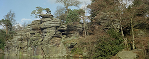
At the surface, weathering (especially frost action) and erosion of the limestone has produced extensive scree or talus slopes beneath the limestone cliffs or scars (19).

Photo: Malham Cove – Limestone pavement above Malham Cove.

Figure: The geology of a typical Dales valley (3D block diagram)
British Geological Survey 3D Ingleborough Model
The British Geological Survey has produced a 3D model of the geology of the Ingleborough area, which may be viewed by downloading the free Lithoframe viewer from the British Geological Survey at http://www.bgs.ac.uk/services/3Dgeology/lithoframeSamples.html.
Superficial geology
The model contains three areas of Worked Ground (quarries), one (Ribblehead Quarry) in the Great Scar Limestone Group in the north and two (Ingleton and Old Ingleton Quarries) in the Ingleton Group in the main valley.
The model contains three superficial units; alluvium from the rivers Doe, Kingsdale and Ribble, peat on the flanks of Ingleborough and till in the southwest and northeast.
The till has been modelled in areas of drumlin development to accentuate the landforms. Till is present elsewhere in the area but is not displayed in the model. The till in this region was laid down by the Devensian ice sheet, which covered the whole region.
Bedrock geology
The bedrock geology comprises several distinct layers. The youngest late Carboniferous deposits of the Pennine Lower Coal Measures Formation comprise interbedded sandstones, siltstones and mudstones with several coal seams.The early Carboniferous limestones of the Great Scar Limestone and Yoredale groups contain classic karst features such as Gaping Gill. The limestone sequence is up to 500 m thick and dips to the northeast at about 5 degrees. The Craven Group, mid – to early – Carboniferous age comprises deeper water mudstones, limestones and sandstones.
In the south west, the Dent Formation, of Ordovician age and comprised of shallow marine sediments, limestone and pyroclastic rocks is encountered south of the North Craven Fault. Most of the area is unconformably underlain by the Ordovician (now attributed to the Precambrian) Ingleton Group of sandstones, siltstones and conglomerates, which is over 300 m thick.