


 During the Carboniferous, a series of geological blocks and basins developed in northern England, and the project area was located at the southern edge of the Askrigg Block and the northern edge of the Craven Basin, the dividing line being the Craven Fault System. A Transition Zone has been identified between the North Craven and Middle Craven Faults. Movements of the system have played an important part in the geological history of the area. During periods of uplift and/or a fall in sea-level deposition ceased and erosion occurred producing an unconformity.
Ancient continental drift, at a couple of centimetres a year, powered the mountain building, and it also moved continents, so that by the start of the Carboniferous Period some 354 million years ago the area lay in tropical latitudes. Shallow sea water lapped over the worn-down Silurian and Ordovician rocks depositing the conglomerates and sandstones of the Ravenstonedale Group. They can only be seen in the Sedbergh area and in small outcrops east of Horton in Ribblesdale.
 Around 335 million years ago, warm tropical Carboniferous seas covered the area (6). They were full of life, and as these creatures died, the calcium carbonate from their shells and the sea was deposited on the sea-bed to form the horizontal layers of the Great Scar Limestone Group on the Askrigg Block and the Craven Group in the Craven Basin.
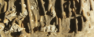
The Carboniferous Limestones were laid on top of the eroded, steeply dipping older rocks, producing what geologists call an unconformity. This is where there is a time gap between the layers of younger and older rocks. Those in between are simply missing (7).

 Photo: Combs Quarry – Combs Quarry, Ribblesdale – Almost horizontal Carboniferous Kilnsey Limestone unconformably overlies Silurian Horton Formation.
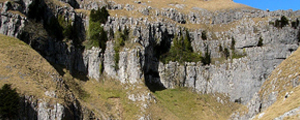
Along the southern edge of a shallow tropical lagoon in the sea, limestone reefs developed, and now form the line of hills or knolls between Settle, Malham and Grassington.

Figure: The Craven Reef Belt © BGS (NERC)


Figures: Structure and typical fossils of the Craven Reef Belt (Reef frame, upper, lower, section) © YDNPA

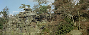
Photo: Swinden Quarry exposes a rare section through one of the Craven reef knolls